Wednesday, October 20, 2021

North to Garibaldi May 2021

 As the pandemic continued to keep us at home in January I managed to find a night over looking the Pacific at Harris Beach State Park.  3 nights at Harris Beach then turned into a short adventure.

May 8, 2021

During the rains that we did get in February the Last Chance Grade between Orick and Crescent City slid closing 101 and causing a 2 hour detour to get to Crescent City.  At that point I decided it would be prudent to stop for a night in Humbolt Redwoods State Park.  

We drove passed our Burlington Campground which would be our stop for the night and continued on to the Founder’s Grove where we hiked the trail and had lunch.


This incredible Redwood grove, located just off the famous Avenue of the Giants, is home to some of the tallest trees in the world. At the end of the loop is the magnificent fallen Dyerville Giant. The giant redwood once stood 362 ft. tall and was considered the tallest tree in the park before its fall in 1991. The redwood’s crash to the ground moved the earth so much that it registered on a nearby seismograph and one local, who heard the impact from half a mile away, thought a train had crashed. Today you can walk the whole length of the tree and stand in awe of its massive root system beautifully on display.   Dyerville Giant Facts: 362 ft. in height 17 ft. diameter 52 ft. circumference Possibly 2,000 years old.


As we hiked the loop we heard a loud crack as this branch came down right in front of us.


Our campsite for the night was site 55, a large site between 2 hiker biker camps.  Very quiet, except for the Varied Thrush with his electronic sound at dawn and dusk.

May 9 -11


On our way to Brookings we made a stop for a walk around the Arcata Wild Life Preserve.  The wind was blowing pretty strongly keeping the birds out of site.


Campsite 18 at Harris Beach


We spent the 10th walking on the beach and at the camp, Terri and Vance joined us after noon.

The 11th we visited hiked Chetco Point and visited the Brookings Botanical Garden, which was very sweet, before stopping for an early dinner at The Hungry Clam where the halibut fish and chips never dissapoints us.

May 12

Our destination for tonight was Umpqua Lighthouse State Park.  We stopped to stretch and go for a short walk at Arizona State Beach where we had an Osprey watching the pond from above and violet green, cliff and swallows and a cormorant caught a fish out of the pond right in front of Mark!

Stopped for lunch at the Rocky Point  park and had to eat in the car because of the mosquitos.  Hiked into the nature preserve and up into a Myrtle wood grove.


Umpqua Light aHouse State Park was very lush.  Our campsite was near the entrance station with a big hill to hike if you wanted to take a shower or deposit your trash.

May 13

Before parting ways with Terri and Vance I hiked down hill to lake Marie for a hike around Lake Marie.

We spent most of the day driving without many stops.  We did drive through Beverly Beach State Park near Lincoln City, a campground I’ve never been able to get reservations at.  It’s east of the highway with a pass under the highway to a beautiful beach.  Sites available now!

I found Munson Creek Falls Natural Area just off 101 it the east before Tillamook, a lovely place where we were able to get out of the wind and walk and picnic.

When we pulled into the Harbor View RV Park we were one of 6 RV’s here for the night.  When I reserved I made sure I could get a bay front site.  


We walked over to the harbor area and met a guy who was tending his sea weed crop.  He lives in Portland and does this on Thursday and Friday.  We took dinner from the Portside Bistro back to the camper and enjoyed dinner as the sunset.  The seafood chowder and a shrimp salad hit the spot.


May 14


Once the coffee was made we headed for the pier we’d been looking at from the camper. As we approached the pier a crow chased a bald eagle who flew out over the bay and circled back to perch atop a tree.  After a bit it grabbed something to eat from the water and landed a top a pilot where he chowed down until the seagulls chased him off,

After breakfast we walked around town and tried to locate the heron rookery that I saw on a promotional map to no avail.  It seems Garibaldi has quite a history for trains and logging.  Now it seems it’s fishing, crabbing and clamming is the draw.  Unfortunately with the winds today and yesterday the halibut boats weren’t going out.  Circling back to the camper we stopped at The Fishpeople Seafood Market where we picked up 8 huge oysters for $5.00 to grill for dinner.

Ghostly Days in the Eastern Sierras - September 2-7, 2021


Along Sonora Pass

After hooking up with Joan and Ted and Terri at the park and ride lot in Cotati we headed for Highway 12 eastbound.  Highway 50, our usual route to Highway 395 was closed due to the Caulder Fire burning adjacent to it and Highway 89.  Our options were either 80, Highway 120 through Yosemite or Highway 180 over the dreaded (so we'd heard) Sonora Pass. 


Another view along the pass

The drive was pretty uneventful.  We made a stop in Jamestown at Railtown 1897 for a picnic lunch.  It was a lovely day for early September in the Gold Country, the temperature was in the mid-seventies.  After lunch we continued on over the mountains and down the pass, which was a slow go with all the twists and turns, but the drive was filled with wonderful granite mountains and unseen territory for us.  Once we were down the mountain we were about 30 minutes from our campsite at Robinson Creek, which was 10 miles west of the town of Bridgeport.

Final view along Sonora Pass

After lunch we continued on over the mountains and down the pass, which was a slow go with all the twists and turns, but the drive was filled with wonderful granite mountains and unseen territory for us.  Once we were down the mountain we were about 30 minutes from our campsite at Robinson Creek, which was 10 miles west of the town of Bridgeport.

Our home for 5 nights, site 9

I was concerned about the campground being overrun since only campground in the Humbolt Toyabe National Forest had remained open when the US Department of Forestry closed all other National Forests because of an inability to protect them if any more fires were to break out.  Surprisingly it was sparsely populated when we arrived on Thursday although it to fill up by Saturday night.  

Regular visitors
The deer have evidently been well fed by visitors as they were not afraid to approach us.  This doe and her fans were right in our campsite.  The next day they joined me down by the creek.  We were also amused by the antics of the ground squirrels as they chased one another around the trunk of a pine tree.  The one that crawled into the truck when I accidentally left the door open, and was closed inside the cab for a bit was not quite so amusing.  We knew he was there by his tell tale droppings.  After searching for him I started banging around behind the seats and he flew out the door past Mark's shoulder just like Rocky the Flying Squirrel.

Along Robinson Creek

The creek was just across from our campsite and we could hear it from our bed at night.

Robinson Creek

Sitting alongside the creek was a lovely respite from the afternoon sun.  Terri and I saw 5 messengers manuevering up the stream. 


Curious about what was on the Bridgeport Reservoir we picnicked at a park along side it and discovered what was there.


The reservoir abounded with birds, there were oodles of stilts, lots more ibis than we saw on our visit to the valley, white pelicans flying along looking for food a tasty morsel, heron and ring neck seagulls.  The RV park was not great, but might be worth a stay just to watch the birds and hookups would make it so the camper could be heated in April!


 Bodie Bluff

The idea for this trip to Bodie State Park came to me when I read about  Ghost Walks  that the Bodie Foundation Sponsors.  We booked reservations in March.  On Sunday Evening at 6:00 we traveled about 45 minutes to Bodie State Park for our tour.  The evening began bright, sunny and warm.  

We were lead by a guide to stations where volunteers roll playing period characters from Bodies past recounted tales of ghosts in Bodies present and past history.


This character from the Wild West recounted the story of Jerry the mule who lived in the mine because he was to fat to get through the passageway and out.


The mine was along the summit of the hill.  Jerry was killed in a fire in the mine.


To this day Jerry is seen walking along the bluff at the top of the hill.

Immigrant from Cornwall

This lovely British lady told the tale of the Tommy Knockers, wee folks who hid in the luggage of miner's from Cornwall who came to Bodie in the 1870's.  The miners were called Cousin Jacks.  The Tommy Knockers would protect the miners and made a loud knocking sound to alert the miners when they needed to get out of the mines.  They also like to play games by moving things and playing jokes.  More information on the Tommy Knockers.


Best role play of the evening!

She told stories of shootings and lynchings.


Lady Jole had lived in this house and she and her husband were upstanding members of the community, articles were often written about them and there participation in local society in the newspaper.  She became ill and the pharmacist prescribed salts.  Rather than salts, she received poison and died.  The house later became the postoffice.  


Lady Jole's chair

Lady Joel was seen recently by a film crew sitting in this chair.


Mrs. Friend

Mrs. Friend's husband had pneumonia and died when she was 22, he was 33.  She was one of 2 undertakers in town.  She recounted the story of the importance of a wake so that there would not be a premature burial.  Loved ones were buried with bell ropes so they could ring the bell if they woke up.  Once someone heard them they were dug up and thus "saved by the bell'. 

 I did find another account which states that it was used in boxing when a boxer was in danger of losing a bout and the bell rang, it was saving the boxer from defeat.

The Dechambeau Residence


Window in Dechambeau Residence where a woman often peers down


By the time we hiked backed to the parking lot the sun had set and the drive back to the campground had become a ghastly adventure!


Here's a link to more of Bodie's ghostly past.


The area we camped in is considered Twin Lakes.  The above photo is of Lower Twin Lake.  All the white on the minarets above the lake is granite.  We were so happy to have a few days that were smoke free so that we could enjoy the beautiful blue sky.


Twin Lakes is a great place to camp and explore the area around 395.  Besides Bodie we checked out another almost ghost town about an hour and a half southeast.  


In 1860s silver was discovered near by Benton and it became busy with competing hotels, stables, saloons, breweries, newspapers and shops. 


The historic general store also served as Wells Fargo station, stagecoach stop and post office.


Bodie was the longest standing mining town rival, Dogtown and Monoville appeared and soon vanished.  In 1883 the Carson&Colorado Railroad built it’s station 4 miles east of the general store.  The town of Benton grew around it and this place became known as Benton Hot Springs.


Sudden deaths that could leave restless spirits were common:  murder, suiside, acute illness, accidents in the mine and mill.  Prominenet citizens included Robert Morrison, a store keeper deputized in 1871 to pursue prison escapees who murdered him at Convict Lake; and F.B. Remington, a proprietor of the store who died right in front of it! The motive for his 1914 suicide by cyanide is still a mystery.


When the silver ran out, the hot springs still flowed.  A series of entrepreneurs appealed to the tourist dreams of their era- hotel, health spa, dude ranch, motel-and the bed an breakfast of today.


The hot spring, it was hot!


On our final day after a lazy morning around camp we drove over to Buckeye Campground, what a spectacular view along that road, and hiked along Buckeye creek, we thought.    We followed Buckeye trail for about and hour past a small meadow and turned around and headed back to the trailhead.  It was well over 80 degrees and getting a bit warm.  

Aspens just beginning to change color.

We continued along the road but made a circle and ended up on Highway 395 north of Bridgeport.  All that hiking had earned us rooter floats in town at the Jolly Cone.

Meadow

We continued along the road but made a circle and ended up on Highway 395 north of Bridgeport.  All that hiking had earned us rooter floats in town at the Jolly Cone.


Tuesday came and it was time to head back over the mountains and home.  Every day when we'd had cell service we'd tried to get reservations at Yosemite for Tuesday so we could stop, but there were no day passes available.
Granite mountainside along Tioga Pass

More granite along Tioaga Pass


We decided to drive through on 120 anyway and at least experience the beauty that is Yosemite from the road, no stops allowed.


Sunday, August 30, 2020

Pacific Northwest 2020

 August 12-13, 2020

North to Redwood National Park

After having had to travel so many times to Orange County and not knowing when or how Bob might need us this year, we hadn’t made any formal travel plans beyond our trip to Arizona in February.  Being unable to even visit our coast during the months of March through June I made reservations for us to visit Prairie Creek Redwoods, a national park campground which was open and taking reservations as of  June.

Thus begins our adventure begins...

.


As we ventured north, we made a stop in Miranda just to see how things were there, this cute little hobbit home was in front of where we parked.


Getting the camper somewhat level in site 18 at Elk Prairie campground was a challenge and used 5 blocks on each side!


Early the following morning we drove out to Gold Bluffs Beach and Fern Canyon.  The road seemed a lot narrower than when last we drove it, probably over 20 years ago in our Volkswagen Van.


When we visited before I remembered  hiking all the way back to Fern Canyon, it turns out we’d only gone as far as the mouth of Fern Canyon.


The hike back into the canyon was spectacular, so lush and green.


One  reason we may not have hiked the whole trail  last time we could have been too much water in this stream.


A wall of ferns, could that be the reason it’s called Fern Canyon?


Later in the day we parked along Newton B. Drury Parkway and had the trails all to ourselves.

We hiked the South Fork Trail to Brown Creek, a little over a mile out and back.  After having passed a lot of people hiking in Fern Canyon we loved the beauty and serenity of being all alone amongst the giant ancient redwoods along this trail.  


Ironically, we spent quite a while at this Goose Pen, caused by a fire years before.  A few days later a lightening caused fire broke out above Armstrong Redwoods and burned along the valley floor.


This burned out cavity in the tree is called a Goose Pen, damage done by a fire which exposes the interior to more fire.  Early settlers used “goose pens” such as this to corral fowl, or even horses, oh my!


I expected a troll to look down on us from above this fallen tree along the trail to Mormond Pond.  We ended up having to turn around because the trail became really steep and the dirt was very lose.


August 15-17, 2020

Farther North to Cape Perpetua, Oregon


In June when I made reservations Cape Perpetua, a park that usually doesn’t usually take reservations, was taking reservations to limit Rangers contact with the public during the pandemic.  

Before exiting California, we stopped in Crescent City on a very clear and very warm day so Mark could do some grunge shooting down at the harbor.


I was disappointed at the wildlife around our campsite at Prairie Creek, so I enjoyed
watching this cormorant sunning himself 


and the sea lions making themselves heard and hanging out,


while the sea gull over sees it all. 

A new spot we discovered last time we were in Oregon was Arizona Beach State Natural Area


We made a stop and watched the swallows darting through the air.  I think they may have been roughed winged swalllows.

By mid afternoon we were settled into site 8 at Cape Perpetua National Scenic Area.


Once again out leveling blocks were needed with  the next door neighbors tent being close enough we had to whisper in the morning,  It would have been a fine campsite if we were traveling with the folks next to us.


but the view was the best!

Before we left the park I walked the park and made a list of all the best campsites, getting level is a challenge in most.


We spent the next morning scrambling around on the rocks along the shoreline.


 I had to stand uncomfortably close to Spouting Horn 


to actually catch it spouting!

We headed back to out camp site for awhile to have lunch and relax before heading back 
down to walk on Cape Cove Beach.


We made the mistake of walking out along the road and north to the parking area for Devil’s Churn and then following the trail down to the beach.  The temperature along the shore was 85 degrees by this time, with the bright sun shine reflecting off the sand.  We looped around, crossed the road and walk back to the shade of our campsite.  We decided its best to use the trail up to and down from the visitor center, a much safer walk than along the highway.

August 16 - 17, 2020

Further North to Cape Disappointment, Washington

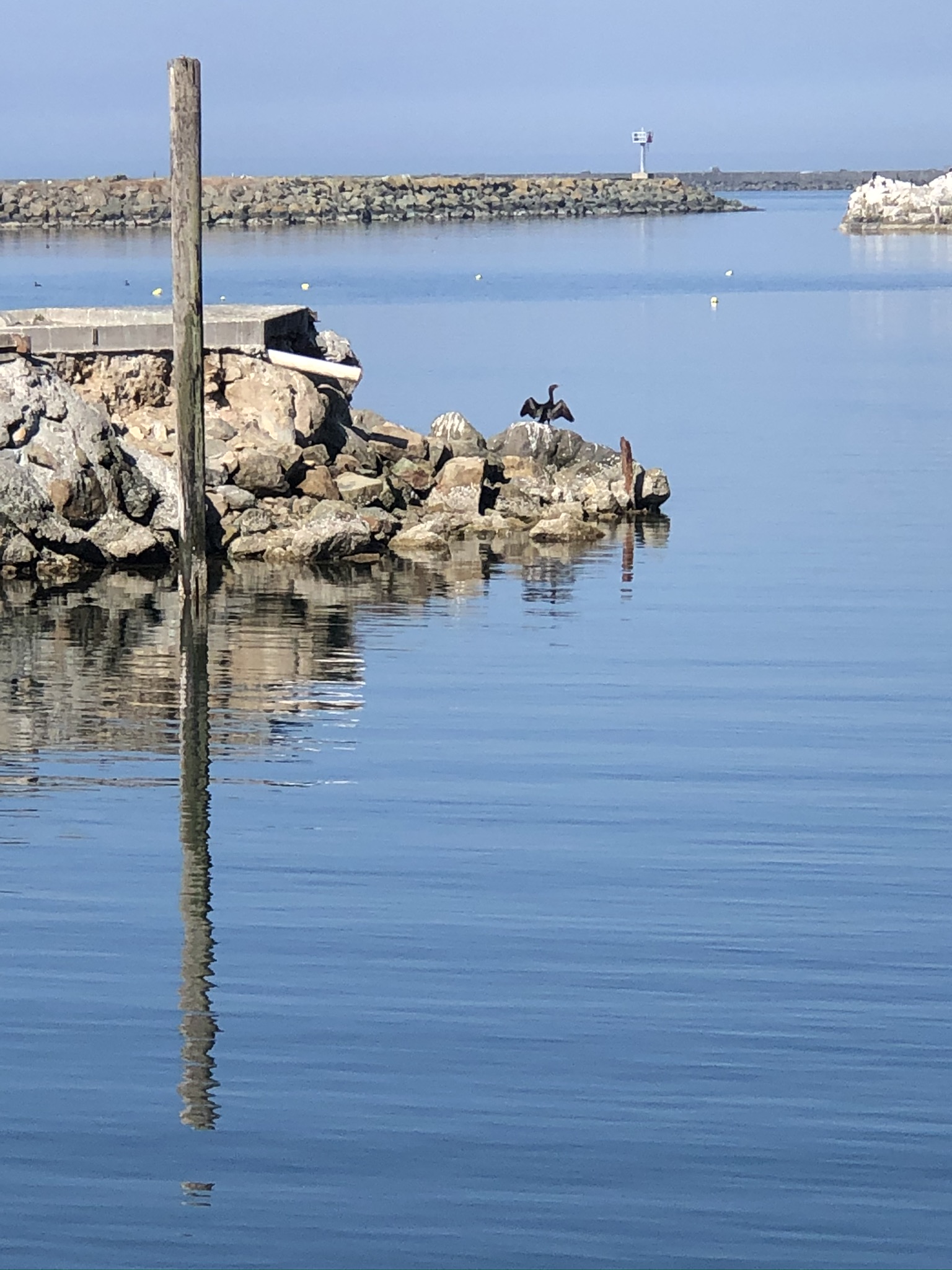
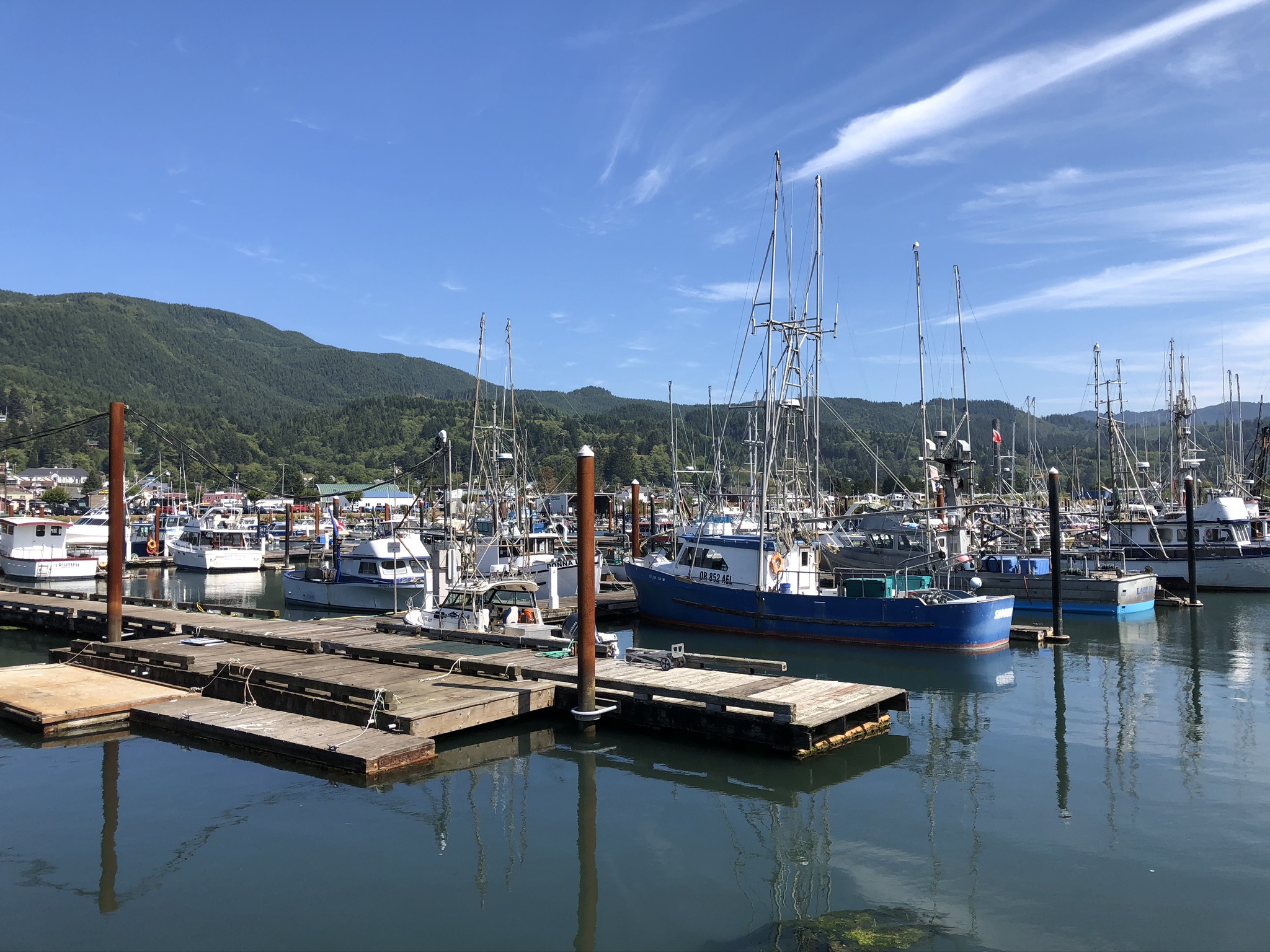
As we were driving north through the very congested northern coast of the Oregon Coast Mark spotted this harbor, always on the lookout for harbor grunge.  We stopped to use the restroom and stretch our legs.  


Doesn’t this whale mural just make you want to return?


...more on that later.

At 2:40 we crossed into Washington and were set up in Campsite C180 at Cape Disappointment State Park.


The only thing better would have been sites 161-170, some of those being almost right on the beach.


Once camp was set up we went for our first walk on this beach.


We were close enough to the beach to hear the waves at night and take another walk out for a sunset shot.  This was the first time we’d camped next to Benson Beach.

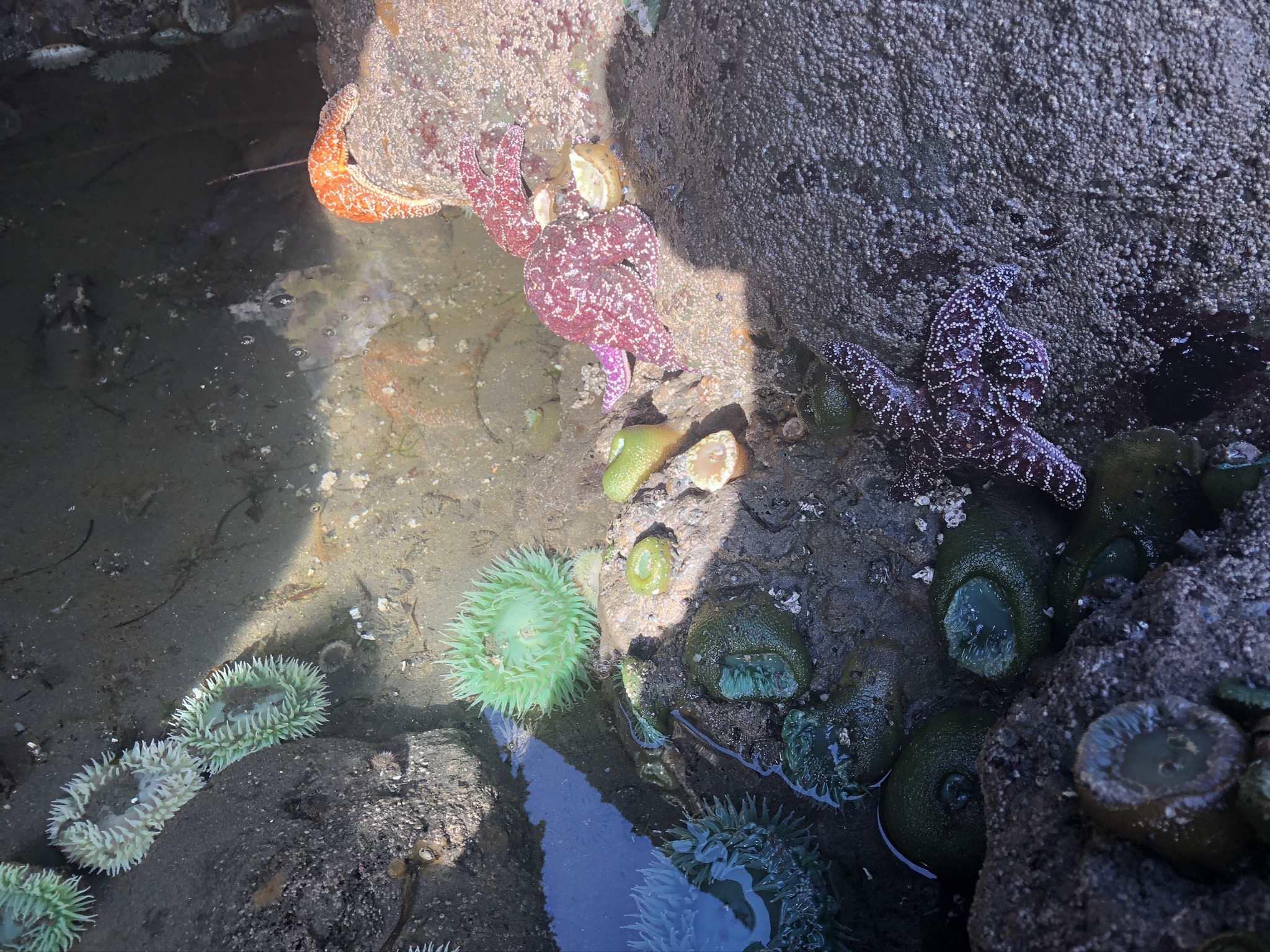
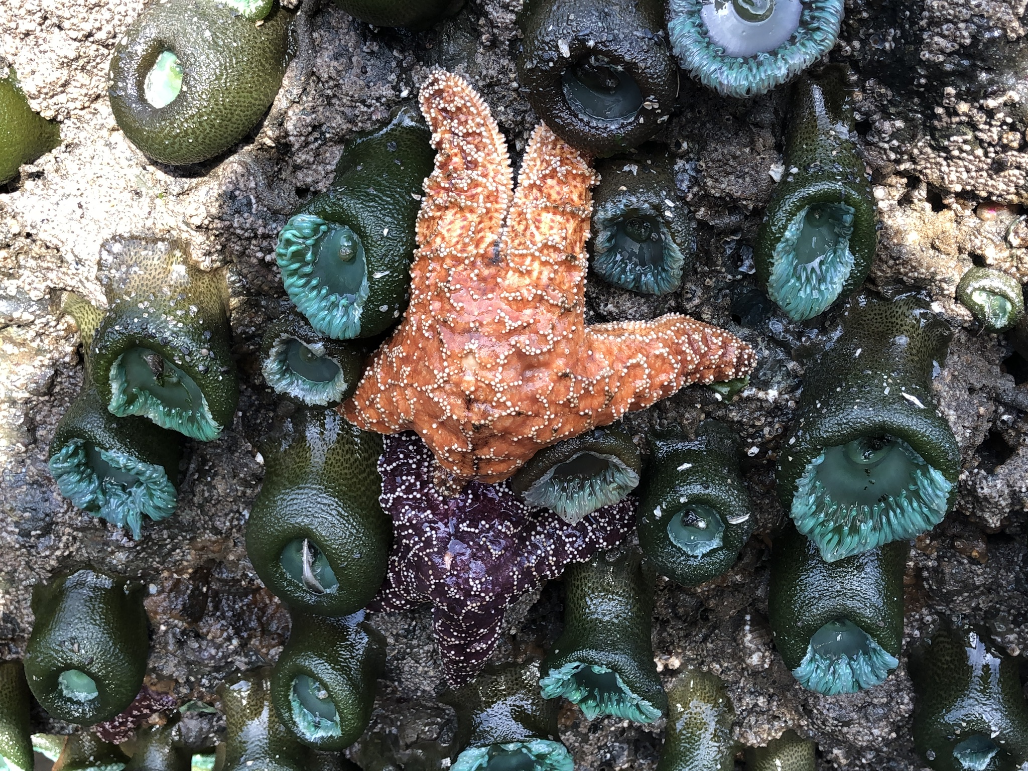
We awoke to a damp and overcast morning and enjoyed our morning coffee during a walk along the beach where the tide was extremely low.  


We spotted live Dungenous Crabs hunkered down in the sand,


as well as this gorgeous purple as starfish, along with snuggled amongst the anemone and barnacles against the rocks.


After breakfast we drove out to the Lewis and Clark Interpretive Center so Mark could hunt for some grunge shots at the military fortification planning to also walk to the South Lighthouse, unfortunately it was closed.  I enjoyed the views from the overlook 


of the cormorants comings and goings from the cliff below.


Since we couldn’t hike out to the South Head Lighthouse, we hike to the North Head Lighthouse, 


which we had spied as we walked along Benson Beach.

Our mouth’s were watering to drive into the nearby town of Ilwaco and have the best crab sandwich we’d ever eaten at Ol’ Bob’s.  

One thing we know for sure these days, is things change.  Ol’ Bob’s had closed, so we decided to try the fish and chips at the only restaurant open in Ilwaco, the pub at the Salt Hotel, next to where Ol’ Bob’s used to be.  


Besides the excellent halibut and chips, we shared a summer salad with strawberries, blueberries, almonds and feta on wild greens with a honey vinaigrette, worth copying, and I enjoyed a yummy raspberry heffervisen  from a local brewery in Long Beach.

This was the first meal we’d eaten at a restaurant since dinner at Topaz Lake on our way home from Arizona in early March.

August 17- 19, 2020

Olympic National Park, Our Destination!

After awaking to a damp over cast morning we wandered down to our final morning at Benson Beach to have a  goodbye walk on the expansive beach where  the tide was out so far.  We had noticed the Dungenous Crabs buried in the sand where the tide had come up the morning before, but our jaws were a gape at what we encountered this morning.


it could best be described as the killing fields, hundreds of Dungenous Crabs washed up on the beach.  They all appeared to be dead.  

By 9:30 we were on our way north once again.


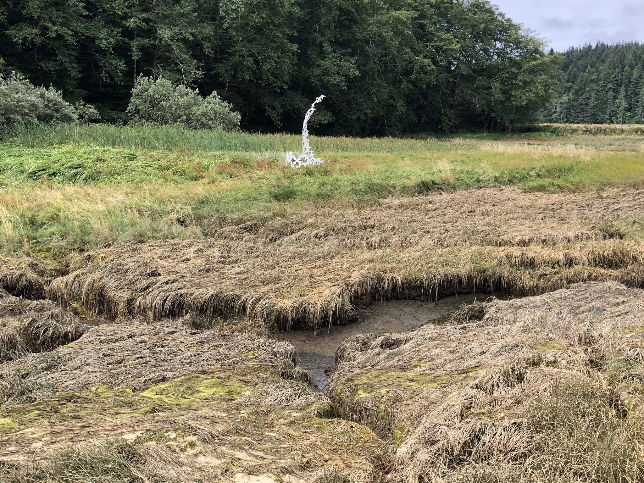
One memorable place we like to stop is the Willapa National Wildlife Refuge Headquarters along Willapa Bay, one of the most pristine estuaries in the United States and with 260 square miles of water surface, the second largest on the Pacific Coast.  The first largest estuary is the San Francisco Bay.


The ecosystems preserved include salt marshes, muddy tide flats, rain drenched
old growth forests, coastal dunes and beaches and freshwater marshes and grasslands. 


A lovely pathway winds along an art trail.


By early afternoon we were settled into our first site of this visit A44, again, getting level was a challenge.


The temperature in Graton this afternoon was a toasty 103 while we enjoyed the 70 degree afternoon.


What a find!


All of the Oyster companies on our way north had been closed due to COVID 19, we felt lucky to find these at Safeway in Aberdeen, had to have our Washington oysters.

Today while driving we heard that a lightening caused fires in Sonoma County were burning above Armstrong Redwoods and along Meyers Grade Road.


On Wednesday morning, we were awake by 5 for the first time during this trip.  Most likely due to once again having the ability to keep up with the world on our electronic devises.  Once our coffee was made we headed down to Ruby Beach to enjoy the sunrise, knowing rain was in the forecast and the tide was at it’s lowest point of the month.  Once we had hiked down the trail to the beach the sun was just poking it’s head above the trees.


While Mark did his thing, I looked for life in the tide pools at the base of the monoliths.


and strolled along the tide line.


The fog was beginning to come in behind this clever piece of beach art.


3 years ago when we visited, people had left cairns near the pathway to the bluff top.
This year rocks had been balanced in crack and crevices of this huge boulder.


By the time we ready to hike up the bluff the beach had become shrouded in fog.

Continuing a bit northward we drove through the town of Forks, Washington, which had been all the rage when Kaci was in High School and reading the Twilight Series, and 14 miles back to the coast and Rialto Beach.  


The drive through the old growth forest was soothing. 
We were surprised to arrive at a parking lot almost full of cars.  


We hiked in both directions along the beach,


looking for shots 


and pebbles


until we would have had to climb a horizontal tree to continue.  

We arrived back at Kalaloch to thick fog and moved into our new campsite,


Site B5.

By morning things were pretty drippy, which was novel at first.  We stayed in our site until checkout time and then, Needing tosite had little connectivity, waited down the street at the range station until 1:00 when the kiosk was to be manned and we could ask to switch sites.  We drove around and found the sites with the best connectivity since we knew we were going to be inside, we wanted to watch the final night of the DNC.

August 21 - 24, 2020

The Journey Home

The rain continued all night and this morning and was no longer novel, it had become a pain in the neck.  We were packed up and on the road by 7:30, hoping to drive out of the rain.  About 20 minutes south of Kalalock the sky began to lighten up and the rain become much lighter.  

As we were driving I received the news about the fire at home on my phone.


We knew the fire was close and that we may be told to prepare to evacuate, Kaci had received the warning the day before.  After the difficulties evacuating last year we had said we would leave during the warning time.  But, we weren’t home so we just needed to send in the kids to get our important documents.  As we drove we were pondering where we might stay if need be.  

I was monkeying around with my phone after we stopped for gas in Aberdeen and not doing my job as navigator.  At one point I looked up and we were crossing a bridge with an open oyster shop below it, I figured it was just on the wrong side of the road and hadn’t seen it on our way north.  We stopped in to see if they had block ice and as we returned to the highway I noticed a sign that said Washington 105.  105?  We were suppose to be on 101!  As we left Aberdeen, Mark followed the signs to Grayland and Raymond,  rather than Raymond and South Bend, driving around a peninsula and turning a 25 mile drive into a 50 mile drive.  It turned out to be a much more interesting drive, even if it added an hour to our already long day's drive.  I think we may have camped in this area in the van when the kids were small.


We arrived at our site in the Harborview RV Park in Garabaldi, which we had discovered on our way north, around 1:30 


and enjoyed the view from our back door for most of the afternoon as the rain continued.  About 6 the rain stopped and the sun came out giving us a chance to walk around the harbor and grab a take out dinner from The Fisherman’s Corner Restaurant.  Not the greatest fish, shrimp and chips we have had.  Usually I read yelp before we eat in an unknown restaurant and when I did that earlier in the trip I didn’t remember hearing of this place.  Should have gone with what I’d read was good and where one of our local neighbors had eaten for 2 nights in a row, Garibaldi Portside Bistro.


In the morning we awoke to heavy drippy fog that gradually revealed the sun.


  We decided to take advantage of the amenities and do our laundry, just in case we were told we had to evacuate at home.


We also toyed with the idea of canceling our reservations for the next 2 nights and staying here until we knew we could return home, but we knew we couldn’t stay in this site and felt the need to get a bit closer to home.

After our Saturday morning FaceTime Call with Bob we were on the road south again by 10:30.   


Just as we were enjoying the drive south along the Oregon Coast we received the evacuation order we were anticipated.


We intended to have lunch at the Darlingtonia Wayside, but the restrooms were closed, so we just stretched our legs with a walk along the trail


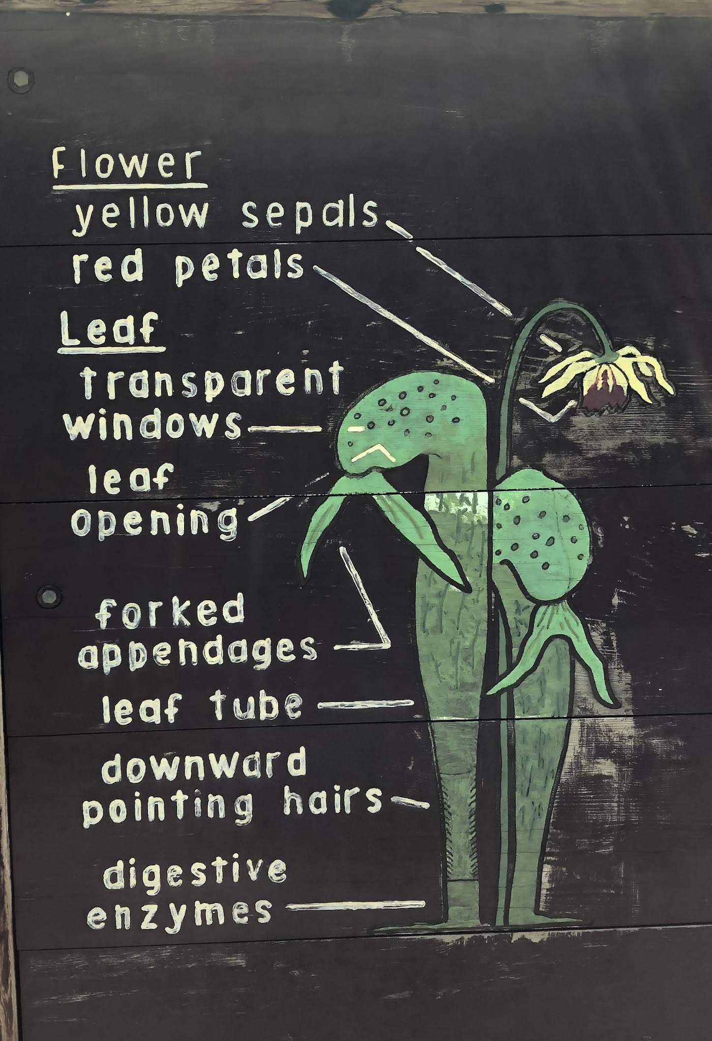
and through the bog filled with insect eating Darlingtonia.  The sign describing them read:

“These cobra-like plants, Darlingtonia California, are found natively in bog areas of Northern California and Southern Oregon.  They flower in May and June with hanging blooms of yellow and red and produce up to a dozen leaves per plant.  Erect seed pods remain most of the summer.  

Insects are lured into the leaf openings under the hood by nectar on the colorful petal-like appendages and the edges of the opening.  Once inside the hood the insects become confused by the many transparent areas in the upper parts of the leaves which appear as exits.  Keeping a foothold on the glassy smooth upper surface of the tube is difficult and eventually the insects are trapped in the lower tube by sharp downward pointing hairs.  After falling down into the pool of liquid at the base of the leaf, the captive is digested and absorbed as food through the plants thin lower walls”

These are what they sell at California Carnivores in Sebastopol.  There is also a trail with them up near Crescent City.


We decided to stay the coarse and continue on for our night in Bandon and regroup down there.


Every time we visit Bandon it seems to be very windy, Bullards Bay campground has spacious sites out of the wind.  I was impressed by all I saw in the loop where A 44 was.  

The only way to stay longer in this park would have been to reserve 24 hours ahead, so the following morning we continued southward and looked for an RV park where we could be comfortable for the time until we could continue on home.  We did find one park in Brookings, Riverside RV Park that looked good on a drive by and in reviews written, but was closed due to COVID-19.  Once in California we drove through a park near Crescent City, but decided to continue on to Patrick’s Point.  At about 2 we got the update that our evacuation had been downgraded to only a warning.  


While Mark rested from all the driving, I tried to stay warm by walking along the Rim Trail


to Patrick’s Point 


And Rocky Point


The walk warmed me well.


We enjoyed our last night in the camper in site number 51 in Abalone Campground.


We left Patrick’s Point at 8:00 and drove into Trinidad looking for something for breakfast.  We stumbled upon the Beachcomber Cafe that makes delicious blueberry and blackberry scones, and other yummy looking treats.  The teachers at the elementary school across the street were arriving to start their first day of distance teaching.  


This week I read an article of in House Beautiful Magazine entitled: 60 Charming American Towns Worth You Haven’t Heard of but Should Visit ASAP, Trinidad was one of the charming  towns listed, we would have to agree.

As had been the pattern the past few mornings, as we traveled south we got a Nixel Alert, todays telling us that we were not longer living in an evacuation warning zone.  Making our decision to travel to our home sweet home the right one.

Once we began to approach Willits you could feel the smoke in the air and it was like thick fog obscuring the mountains through Ukiah.  We expected it to be as thick as we traveled into Healdsburg and the Santa Rosa Plain, it was smoky, but nothing like poor Ukiah and Cloverdale.


At home there was a coating of ash everywhere and smoke hung in the air.

Seven days later, as I write this, the fire has burned along the base of the Ancient Redwoods in Armstrong Redwoods and is still smoldering above Rio NiƱo, at 55% containment.