Wednesday, July 31, 2013

June 1, 2013 - Leaving Santa Rosa


We left home a little before 7.  After fueling up we stopped for breakfast at the Hole in the Wall Cafe in Sebastopol, where we met Joan and Ted.  We were on our way at 8:20. 


After making a pit stop in Manteca, we lunched alongside Yosemite Creek on Tioga Road at Ten Lakes Trail Head.


About a 1/2 mile down the road, at Olmstead Point, we spotted this!  We were looking at the back side of Half Dome!
L

Looking east from the pullout we could see Tenaya Lake in the distance.  I was awestruck by the beauty and didn't remember this area being so spectacular over 25 years ago on my last visit.  So glad we decided to cross over the Sierra Nevada's at Tioga Pass on our journey east!

After a quick stop at the Mono Lake National Park Visitor Center to find out about local campsites, we were sent back in 88National Forest to find dispersed camping at Sagehen Meadow.  The ranger mistakenly told us that it was too warm for mosquitoes.


I was surprised to find a pine forest so close to Mono Lake.  The clouds in the sky produced a beautiful sunset, including large bats.  As we walked around the campsite, we found paw prints of a very LARGE feline.  Early to bed after a long days drive.

June 2, 2013 - Nevada


A little before 8 we were on the road for our voyage across Nevada on the Extra Terrestrial Highway.  Our first stop was for the ever elusive gas station in Benton, CA.


As we traversed Nevada, this is what we saw, lots of straight ahead 2 lane road.  Stopped again for gas in Tonopah, we were now following the 1/2 tank rule we learned in Alaska, when the tank gets down to 1/2 a tank you stop an refill asap!  The next gas station would not be for another 163 miles.  Leaving Tonopah we passed a missle range, Joan remembers camping in this vicinity with mom and dad, watching nuclear bombs being set off in the early 50's!  In over 100 miles we passed less than a dozen cars. Nearing Caliente as we went through the passes Joshua Tree Forest began to cover the hillsides.  The final pass, Oak Springs Summit was covered by a Juniper Forest.  The landscape has changes from brown to green as far as the eye can see.  The temperature dropped from near 93 in Hiko, Nevada to 86 as we come off the summit.


 We arrived at our campsite at Cathedral Gorge State Park at about 3:00.  


At over 90 degrees, it was too hot to go exploring.  We spent the afternoon trying to stay out of the sun.

June 3, 2013 - Into Utah


 We were up early this morning to enjoy the cool of the morning.  


 After a wonderful shower, we explored the slot canyons of the caves.  


Had we continued on the trail we were on we would have cone to this!  This would be a wonderful park to spend more time at in the spring or the fall. 


In a matter of a few hours we were up at 9,000 feet hiking to view the head waters of the Virgin River, 21 miles from Zion Narrows.  


It was sad to look out and see the large span of dead pine trees, killed by the Western Pine Beetle.


At the end of the trail we found a large forest of Bristle Cone Pines.  These trees have survived for over 4,500 years!


After our short hike we drove in to Cedar Breaks National Park.  The road had just opened, but none of the visitor cervices or campgrounds were open yet. 


 Mark was excited to find the large spans of Aspen Trees he remembered from our visit 27 years ago.  We drove up the park road and never found them.


As we were driving out Highway 14 on our way to Zion we found the large stands of Aspen trees that Mark remembered, unfortunately they had yet to leaf out.  We stopped for lunch at Duck Lake and found the above grouping of Aspens.  On our way downhill to Zion, where the temperatures are sure to be above the 60's!

Certainly don't remember the drive into Zion being as spectacular as it was today.


Once we were settled in our campsite we walked to the visitor center across from the campground and caught the shuttle to the end of the line at the Riverside Trail.


 Joan and I walked up to the beginning of the Narrows of the Virgin River.


                                         The view is we walked out of the canyon.

June 4, 2013 - Zion

After saying good bye to Joan and Ted as they travel to the North Rim of the Grand Canyon we headed for the shuttle and Zion Canyon


Before the weather got too warm,  we decided to hike up out of the canyon to Lower Emerald Pool.

A shady resting place along the trail.


 Looking back to where we had begun our 2 mile up hill hike.


After lunch back at our campsite, we headed up to the higher elevations in the air conditioned car to escape the heat.

June 5, 2013 - Bryce Canyon National Park and Kodachrome State Park


Up at 6:30 and enjoying the cool breeze this morning, rather than the howling wind of yesterday evening. Made coffee and got on the road to Bryce.  We arrived at Bryce Canyon National Park around 9:30.  


Clouds were beginning to roll in, keeping the temperature down.

Natural Bridge, Bryce National Park


Fairy Land Point, Bryce National Park


Yovimpa Point, Bryce Canyon National Park, 9,400 feet

When we reached the end of our drive through Bryce we were on the Paunsaugunt Plateau, which used to be connected to the Aquaris Plateau 30 miles across the valley.  16 million years ago, when the Rocky Mountains began rising, north south faults split the table land into seven separate plateaus.  At the southern end of the park where we were is 9, 105 feet above sea level, almost 2,000 feet higher than the Aquaris.


We left Bryce and continued on Highway 12 to Kodachrome State Park.

Arriving at Kodachrome State Park.

The formations are made of a formation of sandstone called "Entrada" formed during the Jurassic Period.


Campsite 11 Kodachrome State Park


Our campsite was # 11.  Spaces 12, 13  and 14 were fantastic.  All spaces on the outside of the loop were good. It was a challenge to stay in the shade for the afternoon.  We hiked over the rocks, where Mark found one of his shots, and along the nature trail that had nature quotes along the way.  Lots of hiking and off roading could be done from this park.  The facilities were good, free showers.  The stars were wonderful. 

June 6, 2013 - Escalante Grand Staircase National Monument and Captol Reef National Park


Awoke to yet another breezy morning, but it is cool!  We were heading back to Highway 12 and Capitol Reef by 8:30.  As we drive north on Highway 12 we pass through a small portion of Escalante Grand Staircase National Monument.  It is the top most step in three staircases.


Driving along the Escalante River.

When we arrived at the town of Bolder, Utah, after finding ice, we went to the Inter-agency Visitor Center and asked what we could see in a few hours.  We were directed to a number of dirt roads.  We decided to do a portion of the Burr Trail, which in its entirety takes you to the road that leads to the Colorado River (Don't they all?).

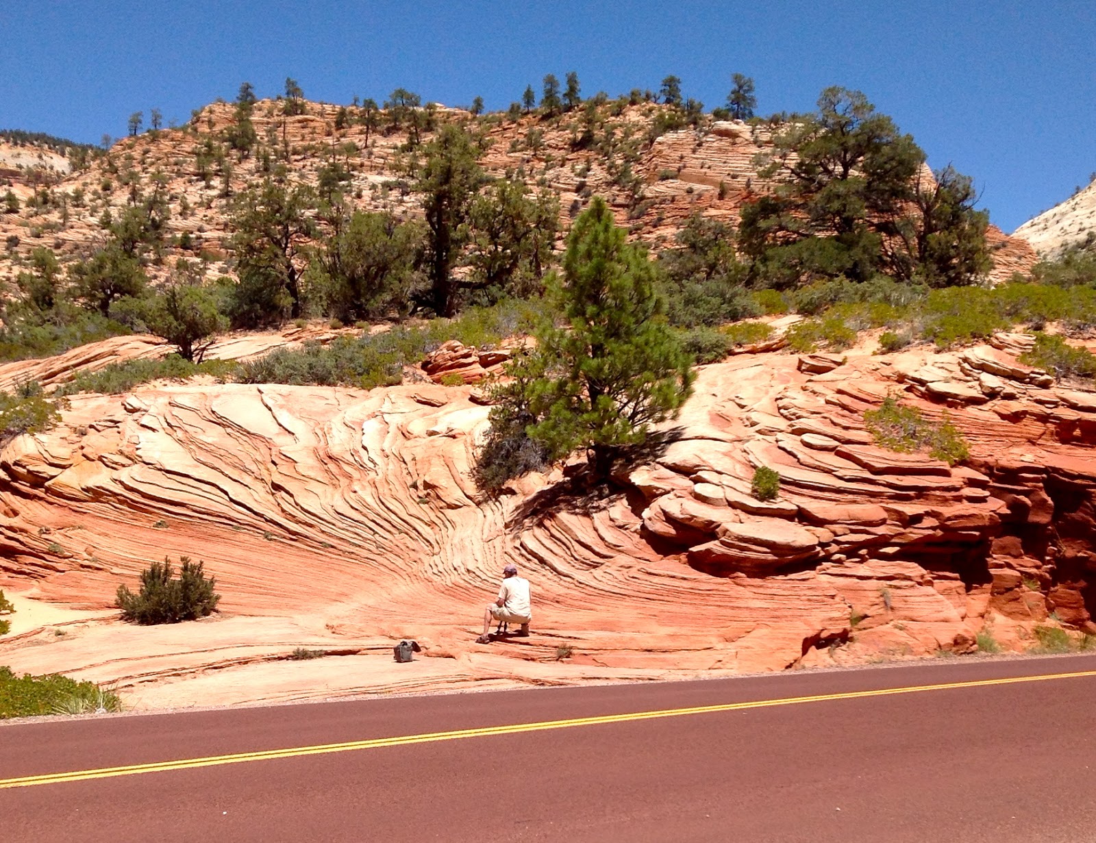
The beginning of The Burr Trail, Escalante The Grand Staircase National Monument


Mark and I found this slot canyon from the description the Ranger gave us at the visitor center.  Good thing I hadn't read that rattlesnakes like to hang out in the before Mark and I hung out this nice cool on for about an half an hour!

Along The Burr Trail 

Burr Trail

This is where we decided to turn around, looking at Capitol Reef and driving down, down, down!


After a diverse drive through rocks covered by Utah Juniper then miles of Aspen forests we arrived at Capitol Reef National Monument to find the campground full.  We drove into the visitor center anyway, just in case there were sites, even though the sign said no.  We arrived just before the visitor center was to close and the answer was no sites.  The ranger directed us back to Torrey where there were a few RV Parks.  We checked into 1,000 Lakes because it was off the main highway and looked out at a large red mesa.   It turned out to be a great place to stay: dinner was available, swimming pool was welcoming, showers were clean, warm and free, and laundry was close to our campsite.  I hadn't used a coin laundry since last summer so 1.75 for wash and 1.75 for dry seemed reasonable.  We heard the music playing from the outside patio where dinner was served, but passed and cooked our own.  We did purchase some yummy home baked bread to accompany our dinner.  Muffins were available in the morning, but not until 8, so we didn't put in an order.  The owner says she does all this to cater to the Europeans who arrive in the large RV's and don't want to drive to find food.  When we were registering a German Couple came in who had visited a few years ago, they brought back the paper with the site they had before and wanted again.
Turns our the campground at the National Park was down in a hole and probably would have been hotter than where we stayed.

June 7, 2013 - Capitol Reef National Park, Goblin Valley State Park and Dead Horse Point State Park

We were up early so Mark could catch the sunrise over the red mesa.  I took advantage of the free WiFii to catch up on e-mail.  We were packed up and on the road by 8.

 We decided to take the scenic drive through Capitol Reef National Park.  We saw this dirt road and it called to us.  We drove to the end of Grand Wash, it was! 


When we left Fruita at 11, the temperature had already climbed to a warm 86 degrees.

Factory Butte


 The scenery as we left Capitol Reef continued to amaze us.  We came upon the butte in the middle of the above photo, Factory Butte, and continued seeing it as the road wound north miles later.  Driving east from Capitol Reef on Highway 24 we broke the half tank rule and were relieved to find out that Hanksville had a Shell Gas Station.

 
Goblin Valley State Park


We stopped for lunch miles from anything at Goblin Valley State Park.  Earlier we had noticed deer, or antelope, we weren't sure.  Here we got a good view and could tell they were antelope, must have been playing with the deer.  By 1:45 we were back on the road heading for Moab.

Being left in the dust on Hwy 70 by an Airstream

As we approached the 70 Freeway, we realized that we had not been on a major freeway since leaving 395 in California.  This shot was taken as we were on that freeway, with a truck pulling a trailer traveling at 70, the speed limit.  We decided to pass the turnoff for the park where we would be spending the night and drive into Moab and have a late lunch, early dinner and buy some groceries.  It was 3:30 by the time we arrived in town.  We stocked up at the first "real" grocery store we'd seen in 6 days.  It was part of the Ralph's Grocery Chain.  Walking through town we spotted the Slickrock Cafe and had a burger and beer.  After walking around the town a bit we arrived at our campsite at Dead Horse Point State Park.  Our site had a cover over the table and electrical hookups.  Another nice Utah Park.  Nice restroom, but no showers.


After setting up camp, we headed to the point and watch the sunset.  What spectacular place to watch the sunset. 

June 8, 2013 - Canyonlands National Park and The Arches National Park

Yesterday had been a long tiring day, so we took our time this morning, no sunrise.  After leaving the park and deciding to have a leisurely morning we heard that sunrise from Dead Horse Point was really spectacular.  We left our campsite at 8:30 and drove to The Islands in the Sky District of Canyonlands National Park.  This is where the Green River flows into the Colorado River.

 By 9:30 the temperature was up to 79 degrees.  

Grand Overlook, Canyon Lands National Park

The Grand Overlook would be a great place to be at either sunrise or sunsetIt took us about 30 minutes to get to the far reaches of where you can drive at Canyonlands National Park from Dead Horse Point. It's much cooler up on this mesa than it is down in the flatlands at Moab.

 
Court House Towers, The Arches National Park


You can tell by the clear sky that the day was heating up as we drove into The Arches National Park.  

The Three Gossips

I had wanted to camp here tonight, but was unable to secure reservations.  

Windows Arch


By the time we drove in and hiked to see those that were not too far from the road the heat was getting to us.  We had wanted to see Landscape Arch, but the hike was 2 miles and the temperature was 95.  So at 12:30 we left the river and drove down to the river to have lunch.

After driving along the Colorado River on Scenic Highway for awhile we decided we'd best start heading towards Monticello and decide where we were going to stay for the night.  After we had passed the turn off for the short drive to The Needles District of Canyonlands Mark decided we should drive out there.  We took a road out of Monticello that went up through the forest of aspen, where the temperature was 79,and them back down to Canyonlands.  The ranger at the other section of Canyonlands National Park had told us that the campground in this section of the park was very popular and that we would have to arrive early in the day to get a site.  As we were driving through the forest we spotted 2 forestry campgrounds that were empty that we could drive back to for a campsite for the night if necessary.  The closer to the campground at The Needles, the hotter it became.We were pleasantly surprised to find campsites available for the night at Squaw Creek Campground, so we nabbed a good one.  

Campsite at Squaw Creek, Canyonlands National Park - The Needles District


Since the temperature was 99 degrees at 6:30, we hopped back in the car and went to explore.  After checking in at the visitor center we drove down a jeep trail that was labeled "Colorado River Overlook".  The trail started out sandy, no problem, after about 5 miles we began hitting a lot of rocks.  The first bad place, we had no choice, we had to keep going, our wheels were already on the stair step rocks and we'd missed the turnaround.  After a few more challenging rocky places we decided it was late and we'd had enough, so we turned around and drove back to camp.  No pictures of this intense time.  On the road back I noticed I had a jeep trail guide.  It said this trail had "large stair steps the last 1 1/2 miles".   We probably were to about the last 1/2 mile when we chickened our and turned around.

Once we were back at the campsite Mark set up to catch a sunset photo and I headed over to the ranger program at the campfire less campfire.  The ranger shared Native American Creation Stories.